




Quick Summary
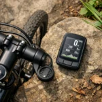
The iGPSPORT iGS800 is a GPS bike computer with a 3.5-inch touchscreen, 32GB of memory and route navigation. Listed features include route re-planning, climb previews, training analysis and Wi-Fi, Bluetooth and ANT+ connectivity.
Key Details
| Detail | Product information and buyer relevance |
|---|---|
| Screen | 3.5-inch touchscreen. |
| Memory and maps | 32GB memory with a built-in US map. Maps for other countries are available to download from the official website; check coverage for your riding region. |
| Satellite positioning | Dual-band L1 and L5 reception, with GPS, BeiDou, GLONASS, Galileo and QZSS listed. |
| Navigation | Can plan routes to saved locations and re-plan a route if you go off course. |
| Connectivity | Wi-Fi, Bluetooth and ANT+ are listed. Check whether your specific sensors or other devices are supported. |
| Ride and training functions | Includes segment functions, iClimb Pro climb previews and training analysis. |
| Battery life | The listing claims 50 hours after a full charge. Actual battery life may depend on use. |
| Dimensions and weight | Listed as 2.36 x 0.83 x 3.90 inches and 0.24 pounds. |
Key Features Explained
Automatic route re-planning is intended to provide a new route after you go off course. Saved-point navigation lets you plan a route to a location saved on the computer. The listing also describes real-time segment display, automatic detection of nearby segments and the option to create a segment.
iClimb Pro provides route previews for climbs. Training analysis is described as analysing training effects, but the specific measurements and methods are not identified.
What to Compare Before Buying
- Map coverage: the built-in map is identified as a US map. Check whether a map for your intended country is available to download and how it is obtained.
- Battery life: 50 hours is the stated claim. Check the exact product information for any operating conditions relevant to your rides.
- Water protection: if wet-weather use matters, confirm the exact model’s water-protection rating rather than relying on a general waterproof claim.
Compatibility, Size and Fit
Wi-Fi, Bluetooth and ANT+ are listed, but support for specific sensors and other devices is not detailed. Check the connection type and compatibility of each device you intend to use. Mounting details are also not specified, so confirm how the computer attaches to your bike.
Plan a Route Around Saved Stops
Before a ride, you could identify destinations or stops and check that they are saved where you can select them for navigation. If you plan to use maps outside the built-in US coverage, check the availability of the relevant country map in advance. A climb preview can help you review a route, but does not replace checking the route itself.
Choosing the Correct Version
Confirm that the product is the iGS800 and that its map coverage suits your riding region. The listing describes a built-in US map and downloadable maps for other countries, but does not confirm that a UK map is pre-installed.
Common Buyer Questions
Does it re-plan a route if I go off course?
Yes. Automatic route re-planning is listed as a feature.
Does it include a UK map?
The listing identifies a built-in US map and says maps for other countries can be downloaded. Check UK map availability before relying on it for navigation.
Will it connect to my cycling sensors?
Bluetooth and ANT+ are listed, but compatibility with specific sensors is not. Check the requirements for your devices.
Before You Decide
Check map availability for your riding region, compatibility with devices you plan to connect, and the water-protection rating if wet-weather use matters to you.