What This Product Is Used For
The Luqeeg handheld GPS land measuring instrument is designed for surveying and calculating land area and distance, offering specialised measurement modes beyond what a basic hiking GPS or manual tape measure can provide.
Unlike standard navigation devices that focus only on location and route tracking, this unit is built for farmland and plot measurement. It supports automatic area measurement, point sampling for polygon shapes, slope based calculation, fixed width measurement and length width measurement.
It is suitable for measuring irregular plots, regular polygons, sloped land and fixed width fields in agricultural or land management environments.
Who This Product Is Best Suited To
This device is best suited to farmers, land managers, survey assistants and outdoor professionals who need straightforward land measurement without complex surveying equipment.
It suits users who measure fields of different shapes and terrain types, including flat farmland and sloped or mountainous plots.
If you want a portable handheld tool with a simple interface and multiple calculation modes, this model is a practical choice.
Pros and Cons
Pros
Multiple measurement modes for different plot shapes
Supports slope based area calculation
Automatic and manual measurement options
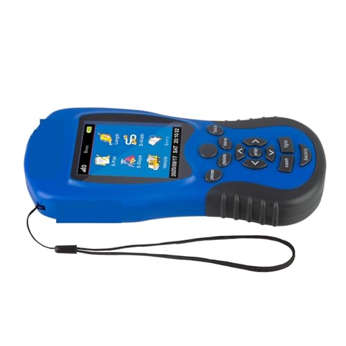
2.4 inch HD colour screen for clear visibility
Portable design with included lanyard
900 records capacity for stored measurements
Cons
Focused on area calculation rather than advanced mapping
Designed for general land measurement rather than professional grade surveying
Real World Performance and Day to Day Use
In day to day use, the 2.4 inch HD colour screen displays area and distance data clearly, making it easy to confirm measurements while walking the boundary.
Automatic measurement allows users to walk the perimeter of a plot and calculate the enclosed area directly. For regular polygonal shapes, point sampling measurement enables manual collection of each vertex coordinate, calculating the area enclosed by those points.
Slope measurement mode supports sloped or mountainous land. You can either manually input slope data or use automatic slope detection, and the device calculates area by applying a slope coefficient to the measured plane area.
Fixed width measurement mode is useful for long strips of land with consistent width. Length width measurement mode supports regular quadrilateral plots, requiring only two side measurements, which are then used to calculate area with an angle coefficient.
The device can store up to 900 records, allowing users to review past measurements without external notebooks.
Why We Like This Product
At YPC we appreciate equipment that simplifies fieldwork. The Luqeeg unit stands out for covering multiple plot types without requiring advanced technical knowledge.
A common mistake is attempting to measure irregular land manually or with single mode devices. Having automatic, slope and fixed width options in one unit reduces calculation errors.
Its portable format and included lanyard make it practical for repeated daily use in farmland or forestry settings.
Comparisons With Similar Systems
Compared with basic handheld GPS units
Basic GPS devices track position and distance but do not provide specialised area calculation modes. This model makes more sense if land measurement is your main goal.
Compared with smartphone area measurement apps
Apps can estimate area but may lack durability and stable outdoor performance. This dedicated device is built specifically for field conditions.
Compared with professional surveying instruments
Professional surveying equipment may offer higher precision and mapping integration. This instrument is suitable for general farmland and plot measurement without the complexity or cost of full surveying systems.
Alternatives Worth Considering
If detailed mapping and boundary visualisation are required, consider a mapping focused GPS unit.
If you only need occasional simple area checks, a basic land meter with fewer modes may be sufficient.
Tips for Getting the Best Performance
Walk boundaries steadily and consistently during automatic measurement.
Use point sampling mode carefully to capture accurate vertex coordinates.
Confirm slope values before finalising measurements on sloped terrain.
Regularly save and review records to avoid data loss.
Charge the device fully before extended surveying sessions.
Full Technical Specification
Handheld GPS land measuring instrument
2.4 inch HD colour screen
Automatic measurement mode
Point sampling measurement mode
Slope measurement mode
Fixed width measurement mode
Length width measurement mode
Supports manual slope input
Supports automatic slope detection
900 records storage capacity
Portable design
Includes lanyard
Buyer’s Guide
Buy this if you need a handheld GPS instrument with multiple land area calculation modes for farmland and plot measurement.
Do not buy this if you require advanced topographic mapping or high precision professional surveying capabilities.
Frequently Asked Questions
Can this device measure irregular shaped plots?
Yes, automatic measurement mode allows you to walk the boundary and calculate the enclosed area.
How does point sampling measurement work?
You manually collect the coordinates of each vertex of a polygon, and the device calculates the area enclosed by those points.
Can it measure sloped land?
Yes, it supports slope measurement with manual input or automatic detection.
What is fixed width measurement used for?
It is used for plots with a consistent width, calculating area by multiplying width by travel distance.
How many records can it store?
It can store up to 900 measurement records.
Is it suitable for farmland measurement?
Yes, it is designed for farmland, logging and land division tasks.
Does it show results on the screen?
Yes, the 2.4 inch HD colour screen displays measurement data directly.
Is it easy to carry?
Yes, it includes a lanyard for convenient portability.
Can it measure regular rectangular plots?
Yes, length width measurement mode calculates area based on measured sides and angle coefficient.
Is this a professional survey grade device?
It is suitable for general land measurement but not positioned as a high precision professional surveying instrument.
Looking for more options?
Browse our full range of Handheld GPS Devices for other great choices to suit your space, goals, and budget.