Quick Summary
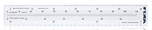
The FlyGA Nautical Mile Scale Map Ruler is a navigation ruler designed to help with map based distance checks for aviation, marine, boating and sailing use. It is described as having a compact 255mm by 38mm size for cockpit use on topographical maps, with outer edges marked for 0 to 60nm in 1:500,000 and 0 to 30nm in 1:250,000.
Who It Is Best For
This is suited to PPL, LAPL and CPL aviation students, experienced pilots, and also marine, boating and sailing captains who need a simple scale ruler for planning and navigation. It may suit anyone who wants a compact tool for working with map distances and scale conversions.
What To Know Before You Buy
The ruler is intended for navigation and diversion work under VFR conditions, and it is described as sufficient for the planning and navigation legs of the EASA Private Pilot Licence PPL skills test.
Pros: Compact size makes it practical for cockpit use, and the marked scales cover several common navigation needs.
Cons: Check the selected use case and map scale before ordering to make sure it suits your exact chart or training requirement.
Common Buyer Questions
What is this ruler used for?
It is used for map based navigation and distance measuring in aviation and marine style planning.
Is it only for pilots?
No. It is also described as suitable for marine, boating and sailing captains.
Does it fit cockpit use?
It is described as compact, with a size of 255mm by 38mm, which makes it suitable for cockpit use on topographical maps.
What map scales does it cover?
The outer edges are marked for 0 to 60nm in 1:500,000 and 0 to 30nm in 1:250,000.
Can it help with training?
It is described as sufficient for the planning and navigation legs of the EASA Private Pilot Licence PPL skills test.
Key Details
| Detail | What it means in use |
|---|---|
| Brand | FlyGA Flight Equipment |
| Product type | Nautical mile scale map ruler |
| Size | 255mm by 38mm for compact cockpit use |
| Outer edge scale | 0 to 60nm in 1:500,000 and 0 to 30nm in 1:250,000 |
| Centre scale | Converts between kilometres from 0 to 110km in 1:500,000 and statute miles from 0 to 70sm in 1:500,000 |
| Intended use | Navigation and diversion planning under VFR conditions |
| Training use | Described as sufficient for the planning and navigation legs of the EASA Private Pilot Licence PPL skills test |
Final Buying View
If you want a compact navigation ruler for aviation planning and chart work, this FlyGA tool gives you a clear set of distance scales in one place. It is also described for marine, boating and sailing use, which broadens its appeal beyond the cockpit. If the scale and intended use match your needs, it is a straightforward choice worth considering.