

Quick Summary
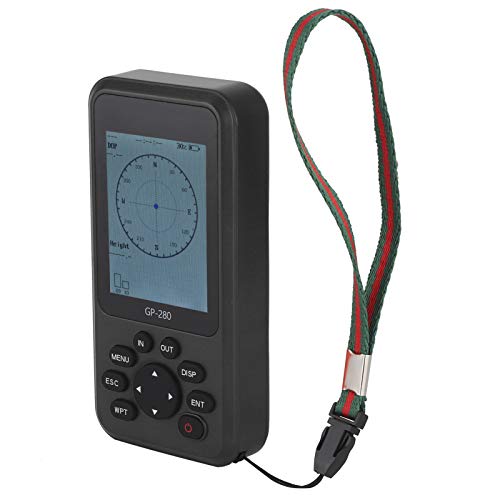
This handheld GPS survey equipment is a rechargeable GPS land meter designed for recording historical data and tracking, with real time navigation for outdoor measuring tasks. It is described as a portable GPS device for measuring length and land area, and it also includes barometer based altitude measurement for use in hilly or mountainous terrain.
Who It Is Best For
This is suited to buyers who need a handheld device for outdoor measurement work across different terrains. It may suit land management, agriculture, forestry, water conservation, taxation, and similar settings where length, area, tracking, and location based records matter.
What To Know Before You Buy
The device is described as a portable GPS tool with a rotating display screen and an intuitive menu, which should help when checking results from different angles. It is also listed as using dual satellite GPS positioning and a GNSS receiving chip that receives signals from GPS, GNSS, SBAS, and Beidou systems.
Pros: Built for outdoor land measurement across several terrain types, with tracking and historical data recording.
Cons: Check the selected variation and suitability for your exact measuring needs before ordering, especially if you need a specific workflow or display preference.
Common Buyer Questions
What does this handheld GPS device do?
It is described as a land meter for measuring length and land area, with tracking and real time navigation.
Can it be used on uneven ground?
Yes, it is described as including barometer based altitude measurement and being suitable for hilly or mountainous terrain.
Is it only for one type of land?
No, it is listed for farmland, grassland, forests, water bodies, beaches, and industrial sites.
Does it record data?
Yes, the title says it is for recording historical data and tracking.
What kind of signal systems does it use?
It is described as receiving signals from GPS, GNSS, SBAS, and Beidou systems.
Key Details
| Detail | What it means in use |
|---|---|
| Handheld GPS survey equipment | Easy to carry for outdoor measurement tasks |
| Rechargeable GPS land meter | Designed for land measuring and tracking work |
| Real time navigation | Helps when moving between points outdoors |
| Recording historical data | Supports keeping a record of earlier measurements or tracking |
| Rotating display screen | Makes results easier to view from different angles |
| Dual satellite GPS positioning | Supports positioning in outdoor measuring work |
| Barometer included | Used for altitude measurement in hilly or mountainous terrain |
| GNSS receiving chip | Receives signals from GPS, GNSS, SBAS, and Beidou systems |
Final Buying View
If you need a handheld GPS land meter for outdoor measuring, tracking, and recording historical data, this is a practical option with broad terrain use. The rotating display, rechargeable design, and altitude measuring features add convenience for field work. If your buying decision depends on a specific setup or variation, it is sensible to check that before ordering.