



Quick Summary
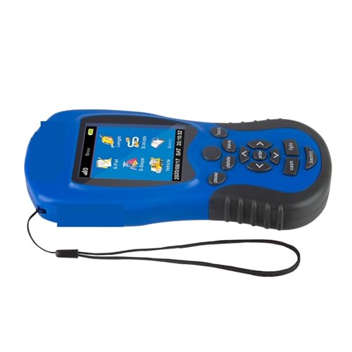
This handheld GPS survey equipment is a portable GPS device designed for accurate length and land area measurement. It combines GPS technology with a built in barometer, and it is described as suitable for use in mountainous regions where altitude data can help with measurement.
Who It Is Best For
This is a practical choice for buyers who need a handheld land meter for outdoor measurement work across different terrain types. It may suit people working in agriculture, forestry, water management, land administration, construction, or other situations where a portable tracking device is useful.
What To Know Before You Buy
The device is described as having an intuitive menu and a rotatable display, which should make it easier to read results from different angles. It also uses a high sensitivity GNSS receiving chip that captures signals from multiple satellite systems, including GPS, GNSS, SBAS, and Beidou.
Pros: Portable, designed for accurate land measurement, and suitable for a wide range of terrain types.
Cons: Check the selected variation and suitability for your exact measuring task before ordering, especially if you need a specific use case or setup.
Common Buyer Questions
What is this device for?
It is designed for accurate length and land area measurement in a portable handheld format.
Can it be used on difficult terrain?
It is described as suitable for mountainous regions and other challenging terrains.
Does it have a display that is easy to read?
Yes, it has a rotatable display that is intended to be readable from different angles.
What satellite systems does it use?
It is described as capturing signals from GPS, GNSS, SBAS, and Beidou.
What kinds of jobs is it suited to?
It is described for use in agriculture, forestry, water management, land administration, and construction.
Key Details
| Detail | What it means in use |
|---|---|
| Handheld GPS survey equipment | Portable format for outdoor measurement work |
| Accurate length and land area measurement | Designed for measuring land related distances and areas |
| Built in barometer | Provides altitude data for use in mountainous regions |
| Rotatable display | Helps with reading results from different angles |
| High sensitivity GNSS receiving chip | Captures signals from multiple satellite systems |
| GPS, GNSS, SBAS, and Beidou | Supports multi system signal reception as described |
| Portable tracking device | Easy to carry for field use |
Final Buying View
If you need a handheld land measurement device with portable handling, multi system signal reception, and a rotatable display, this is a straightforward option to consider. It is especially relevant for outdoor work across varied terrain and for buyers who want a device described as suitable for accurate length and land area measurement. If that matches your task, it is worth checking the selected variation before ordering.